Showing posts with label Mission District. Show all posts

Monday, June 7, 2010

Sunday Streets 2010 Mission Route Announced

Last year's Mission District Sunday Streets event was easily my favorite. There's a real qualitative difference between a long, beautiful, but sparsely activated route like the Embarcadero or Great Highway, and this path through a dense residential neighborhood. The former gives bicyclists a chance to ride free from cars, but the latter makes one big pedestrian plaza out of two of the neighborhood's main commercial drags.

This year's event is bigger than ever, with the addition of Harrison Street to the car-free lineup and a later end time: 3pm. Read more at the Sunday Streets website.

Tuesday, February 9, 2010

A Good Day For Alleys

There's a couple pieces of good news in between all the bitchy comments over at Curbed!

The first concerns a parking lot at 17th and Folsom, behind the old Joseph Schmidt chocolate factory (thanks, HersheyCo!). This expanse of asphalt has, according to Curbed, apparently been planned for a park for some time.

Saturday, December 26, 2009

Wider Sidewalks on Valencia


City workers have been tearing up four blocks of Valencia Street for the Valencia Streetscape Improvement project for about six months now, and concrete results are now underfoot. The first blocks of wider sidewalks have opened and Pedestrians can now enjoy the extra space as well as the safety of some new corner bulbouts. Click through for a larger picture; you can follow the white line of the crosswalk to see the difference between the old sidewalk width (foreground, South of 17th Street) and the new (North, across 17th Street in the photo).

It's clear that there remains some more work to be done on these first blocks: pouring more concrete, installing street furniture, and planting a row of new trees in what was once the parking lane. And work has yet to begin on most of the blocks in the project area (Valencia from 15th to 19th).

But two blocks are open and usable right now, and the rest will follow before you know it. Go out and see for yourself what a difference a few feet can make.

Friday, September 11, 2009

16th Street Upgrades?


If you've been down 16th Street lately you've probably noticed these new poles being installed. They seem to be replacements for the poles that currently support Muni's overhead wires (for the 22 and 33 lines) rather than utility poles.

I haven't been able to Google up any info on this project, but I suspect it might have something to do with Muni's planned (TEP) re-routing of the 22 down 16th to Mission Bay.

Anyone have details?

Monday, August 24, 2009

Laying Better Plans

The Planning Department's City Design Group has been working on its Mission Streetscape Plan for some time now. They've just released the presentation materials from the fourth Public Workshop and the concepts they outline are very encouraging!

I think the grid of the inner Mission District is one of the most pleasant environments for pedestrians in the city. Most intersections have four-way stops, the streets have wide sidewalks, low car traffic and are lined with trees and beautiful houses. But there's definitely room for improvement, especially along the streets that were handed over to cars during the 20th century (So. Van Ness, Guerrero, 16th and especially Potrero).

Check out the PDF, and continue after the jump for my first impression.

Monday, July 20, 2009

Less Median, More Sidewalk

Work is about to begin on the Valencia Streetscape Improvements project. There are a number of elements of the Better Streets "Plan" that will be installed along the four-block stretch in question, but the biggest single change will be the removal of the 13-foot wide center parking lane median and the addition of 6 to 9 feet of sidewalk (half on each side of the street, of course).

According to Streetsblog, Liveable City Executive Director Tom Radulovich "was hopeful that Valencia could serve as a model for many of the ideas that are in the Better Streets Plan." And indeed we all should remain hopeful that more of our street space is turned over to pedestrian use.
Unfortunately, not all street improvement projects currently underway are quite so admirable.

The project to redesign notorious traffic sewer Cesar Chavez Street will not include wider sidewalks but will instead add 14-foot-wide center median to the expressway. Thus ensuring that cars will continue to speed to and from the "hairball" of on/off-ramps below Highway 101 and the street will continue to divide Bernal Heights from the Mission - albeit under the shade of pretty new trees.

Divisadero will also be "improved" without doing much to address the public pedestrian spaces along the street.

Sunday, July 19, 2009

July Sunday Streets

Let's none of us ever buy gas again

I hope everyone had fun at Sunday Streets today. This months fete took the same route through the Mission District as last month's. My impression, however, was that the crowd was slightly different. Last time, there seemed to be more people present along the Easter half, down 24th Street. The crowd then seemed to be simply walking/biking/jogging/what-have-you down the street.

This month, the crowd seemed just slightly smaller but more engaged. I noticed an awful lot of roller skaters, and more people with music systems on their bikes or blasting out the apartment windows above the route.

Last month I left right at 2pm, when the street was reopened to cars. This time I waited until the last possible minute to leave the street. It was a little perplexing to hear the cops yelling, 'The street is now open, please get off the street,' or, 'The street is open, look out for yourselves!' After all, aren't they supposed to look out for us?

Sunday, June 14, 2009

Pedestrianism Vol. 5

Pedestrianism Vol. 5 - Sunday Streets on Vimeo. If you didn't watch it in HD, can you be sure you've seen it?

If you weren't able to enjoy San Francisco's third Sunday Streets event - this one through the Mission District - here's your chance to see what you missed. Thousands of people turned out to enjoy the beautiful weather on June 7th. This video traces the length of the route, from Potrero Avenue along 24th to Valencia and down to 19th Street, where it turns West again into Dolores Park.

Even though I filmed this during the last hour of the event, when crowds had thinned just slightly, it's evident that turnout was high. One really gets a sense for how dense the throngs were along 24th Street, which is a vibrant commercial corridor. Pedestrians were represented in higher numbers here than elsewhere along the route; much higher numbers than in previous Sunday Streets.

Along Valencia people spread out in the wider street, and bicyclists drifted happily through the crowd. Kids on training wheels were at home among roller bladers and skateboarders.

By the time I reached Dolores Park the streets were being turned back over to cars, but as you can see at the end of the video, there was still a demand for the space. Many folks have expressed interest in allowing the event to run later in the day. Who knows, maybe it will.

The next Sunday Streets will again wind through the Mission District on July 19th. I'll see you there!

Monday, June 8, 2009

Mission District Sunday Streets

I hope everyone had a blast at Sunday Streets yesterday! It was the third iteration of San Francisco's ciclovia, but the route through the Mission District brought out a huge, engaged crowd like I haven't seen at previous events.


I was on the street for the full four hours this time. There was so much to see and so many people to stop and talk to that the time flew by! At 10am the first cautious pedestrians and bicyclists ventured onto the asphalt, and before long the crowd had filled the streets.

After walking the length of the route and a brief break at Dolores park, I turned around and walked it again headed East. As I turned the corner at Valencia and 24th Streets i was amazed at the volume of the crowd on 24th. These are people who don't get the chance to appreciate the public spaces in between buildings very often, and who were taking full advantage of the brief opportunity.

Businesses on 24th and Valencia had tables on the sidewalk and people in their shops. Folks on their bicycles intermingled calmly and freely with pedestrians, roller skaters, hula hoopers, and at least one unicyclist.

If you missed your chance to enjoy the neighborhood, then mark your calendar for July 19th. On that Sunday the streets of the Mission District will be opened to people again.

Friday, June 5, 2009

Don't Forget Sunday Streets

This Sunday, June 7th, will be this year's third installment of Sunday Streets. This month's route: the Mission District!

I'm super excited about this route - I predict it will be packed with folks looking to enjoy some breathing room on these typically crowded streets. There are tons of events planned and if the weather holds up the party could overflow into adjacent streets and the three parks connected by the route.

The fun goes from 10am to 2pm this Sunday so don't miss it! Take BART to 24th Street station, the J-Church to Dolores Park, the 9, 12, 27, 48, 33, 53, 14, 49, 26 (while it lasts!) buses and enjoy the neighborhood from a windshieldless perspective.

Wednesday, May 20, 2009

The Next Sunday Streets

This year's third Sunday Streets route has been announced! On June 7th 2.3 miles of streets in the Mission District will be closed outright and another 2/3 of a mile will be open only to local access.

The route will connect Dolores and Garfield Square Parks with Rolph Playground. Activities along the route haven't been announced yet, but there should be little doubt that this route will be interesting.

Thursday, May 14, 2009

Pedestrian Plazas: Next in Line:

With the successful construction and opening of the Castro pedestrian plaza under their belts, DPW and the "Pavement to Parks" program is already looking ahead to its next projects. Meet the next three plaza locations after the jump

Saturday, May 9, 2009

Newsflash: BART Riders Live in the Bay Area's Urban Core


BART has released its one-a-decade census of rider activity. Transit geeks rejoice. BART is even encouraging the statistically-inclined among us to show them things they haven't discovered buried in the data.

Two points from the official intergovernmental web page on the report:
  • More walkers and bicyclists. Compared to 1998, more customers are walking or bicycling from home to BART. (The percentage coming to BART by car stayed the same, and the percentage using other transit to connect to BART went down.)
  • Access modes vary considerably by station. The percentage of passengers driving alone from home is highest at North Concord/Martinez (72%) and lowest at Powell (1%). Walking from home is highest at 16th St. Mission (81%) and lowest at Orinda (3%).

Tuesday, March 31, 2009

Street Closing Fever

It seems like converting streets into pedestrian plazas and parks is the hot new thing in SF. Ever since Streetsblog reported the potential closures in the Castro and North Beach, residents of other neighborhoods have gotten the bug to identify streets in their parts of town that could use the same treatment.
The other day I nominated the two blocks of Treat Ave on either side of 16th for plaza/park conversion.

Yesterday, local hipster blog Burrito Justice posted a proposal to close the last block of Valencia Street, between Mission and C. Chav. (discovered via MissionMission). BJ's plan would be part of an ongoing plan to rebuild St. Luke's hospital.

While both Mission District street closures have some drawbacks that would need to be addressed (emergency vehicle access in St. Luke's case) I believe both streets are underused as vehicle rights of way, and both are in park-poor areas of town with high population density. Both should be seriously considered.

Which street in your hood would make more sense as a park or pedestrian plaza?

Saturday, March 28, 2009

Which Street Would You Close?

Since the city is installing a fast-tracked trial closure of half a block of 17th Street at Market, I can't help but wonder what other cut-off chunks of auto territory would benefit from being turned into mini-parks or pedestrian plazas.

Some folks in North Beach, including poet and City Lights bookstore owner Lawrence Ferlinghetti, want to turn a block of Vallejo Street into a pedestrian "piazza."

What do you think? Which section of street would you like to close?

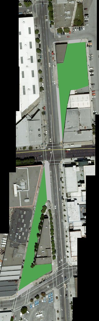
In my neighborhood, I'd love to see the two blocks of Treat Avenue on either side of 16th Street become plazas or parks. The intersection of 16th, Harrison and Treat makes for two of the longest pedestrian crossings I've seen in SF, and devotes a massive amount of space to asphalt that hardly anybody ever drives on anyway.

That space could be converted into green space, which is sorely lacking in the neighborhood. If the city could purchase some of the adjacent parking lots, the park would have a respectable amount of space. Here's an arial view of what could be:

By closing all the gaps in the sidewalk created by Treat Ave, pedestrian safety is improved along 15th, 16th, 17th, and Harrison Streets, while still allowing bikes and pedestrians to cross through the park. The traffic patterns at the site currently prevent very many cars from using these two blocks, and the resulting empty expanse has blight ed the area and attracts prostitution.

Looking North from 16th Street

Challenges to the success of this idea include bringing more people to the area late at night, which would be necessary to prevent the park from becoming dangerous or overrun by prostitution. The surrounding blocks are mostly industrial or office buildings, so there is not a natural population in the area at night. There are, however, several residential developments within a two-block radius, and new development of some of the vacant or underused properties adjacent to the new park could brighten the neighborhood and potentially help pay for the park's construction.

Looking South from 16th Street

In addition, there are a few garage doors on the Southern block and one on the Northern. These driveways are rarely used, however, and cooperation of those propety owners is not out of the question.

The creation of a Treat Avenue park or plaza would take underused asphalt away from cars and allow the neighborhood to enjoy it. Space, especially green space, is sorely needed for the residents of the Northeast Mission. In addition to providing more high-quality public space, the park would improve pedestrian safety at this busy intersection. The challenges that need to be resolved are dwarfed by the benefit this park would provide, and the city should seriously begin studying how to make this a reality.

Friday, February 27, 2009

Western Neighborhoods Plan

Vancouver's about to launch its "Laneway Housing" pilot project. The project aims to encourage owners of single-family homes in the middle of the city to build small in-law cottages on place of existing garages. Apparently garages in these parts of Vancouver front on back alleys, or lanes, hence the name.

The idea isn't without controversy, but the goal is to expand the diversity of housing stock in the city by building small, more affordable units. This would also densify the neighborhoods, meaning more people could live closer to work, grocery stores, etc.

A couple problems with the Canadian plan stuck out to me, including the ability for property owners to keep up to three parking spaces. That would allow the new residents to clog local streets with more cars, rather than increasing the walkability of the neighborhoods.

But the basic idea is good, and worth emulating in the almost-walkable, relatively high-density suburban areas of the Bay Area, including the City and County's own suburbs among the dunes on the West side of town.

Take this random stretch of Judah St. I literally double-clicked at random on MapJack to find this scene. The N-Judah runs in front of these houses night and day, but they all have garages! A decision by the city to allow in-law units in place of those garages would double the density of units in this picture. And all without casting any new shadows or otherwise disrupting the architectural character of the neighborhood.

A zoning change or a streamlined process for building and approving these in-law units would provide financial benefit for those homeowners on this robust segment of rail infrastructure who don't drive much, or might be willing to give up a parking space for some extra rental income.

Our city leaders tell us every chance they get that we need to find a way to fit more housing into SF. Their solution for the last three decades has been to put that in the "Eastern Neighborhoods." These neighborhoods - SoMa, the Mission, Potrero Hill and also Bayview - are being made to bear this load because there are pockets of industrial land that are going out of use for various reasons, but also because it's politically possible to do so; residents of those neighborhoods don't have ebough of voice in city government to stop it.

For reasons worth exploring (but not now) the homeowners West of Twin Peaks have made a political third rail out of any new, dense housing on their avenues. But that's not good for the city. It will cost a lot of money, out of public and private coffers, to put 10,000 units of housing on the East side of town.

Most of the new housing will be on the formerly industrial land, which often lacks sidewalks, adequate street lighting, traffic signals, sewers, even properly paved roads. And once those units are built the residents will have to squeeze onto those bus lines that survived the TEP axe.

On the West side of town, however, four of Muni Metro's light rail lines already run through some of the lowest-density residential areas of SF. Almost every unit within a couple blocks of the K-Ingleside, L-Taraval, M-Oceanview and N-Judah has a garage. If it were easier (or even possible) to convert those garages into small apartments, this area of town could absorb 10,000 or so of them over the next 20 years with much less pain. And these new units would be truly Transit-oriented development.

Outside of SF, East Bay and Peninsula counties could use rezoning strategies like this to densify corridors along new light rail or BRT lines. Using tax revenue capture programs, they might even choose to fund the capital costs of those lines by encouraging this "laneway housing."

Every city and region has their own needs, but a properly-tailored plan for this kind of infill housing can steer development away from the exurbs and into existing neighborhoods, without many of the external costs that come when big development corporations raze and rebuild sections of the neighborhood fabric.

Monday, February 23, 2009

East Bay Livable Streets Meeting Tomorrow Night

Walk Oakland - Bike Oakland is a great group that's working to make the East Bay more bicycle- and pedestrian-friendly. They're having their monthly volunteer meeting tomorrow, Tuesday, February 24th from 6:30pm - 8:30pm. The meeting will be held at Bay Area Wilderness Training. 2301 Broadway, Suite B (Enter on 23rd) in Oakland.

From Dominic R Lucchesi, an admin of WOBO's Facebook group:
Please join us tomorrow night for WOBO's monthly volunteer meeting. This time around, we will be discussing our next pedestrian campaign, as well as getting updates on the Bike Broadway Campaign. Hope to see you there! (And bring yo' friends!). Yummy snacks will be provided.
It's been added to the calendar in the sidebar. Facebook event here. Those of you concerned about ped/bike issues in the East Bay should make it a a point to attend.
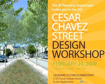
For SF livable streets issues, remember to attend the Cesar Chavez Design Workshop. That meeting is also tomorrow, from 6:30 - 7:45pm at the Leonard Flynn Elementary School Auditorium, 3125 Cesar Chavez Street in SF.

Wednesday, February 11, 2009

Cesar Chavez Design Workshop

The Planning Department's City Design Group will hold its third and final workshop on a redesign plan for Cesar Chavez street between Guerrero and Hampshire:

Tuesday, February 24, from 6:30 - 7:45pm
Leonard Flynn Elementary School, Auditorium
3125 Cesar Chavez Street

I've added this to the calendar of important events in the sidebar. Unfortunately, until someone makes a decent calendar widget for Blogger, you'll have to deal with the narrow columns of text or click through to the full Google calendar. Check the calendar often for reminders about important meetings and deadlines like this.

This is the last C. Chav workshop, which means it's your last chance to weigh in on what will be the first street redesign using the Better Streets "Plan" guidelines. Make it count!

Thursday, February 5, 2009

Pedestrianism Vol. 3


Pedestrianism Vol. 3 from Josh Bingham on Vimeo.

In this video I experimented with night time, longer exposure pictures for the time lapse. The result is something like a drunken stumble. This is also the first Pedestrianism video that is HD by Vimeo's standards, so I recommend viewing in full-screen mode with scaling off.

The walk cuts across a northern section of the Mission District, along Mariposa, 17th and 16th streets. With the low frame rate you may be able to pick out some landmarks and get your bearings, if you are familiar with the area.