Wednesday, December 31, 2008

From Congestion Pricing to the Geary Corridor

Wow, check out the comments below this Calitics post on the pre-premilinary congestion pricing plan for downtown SF. The topic quickly digresses to the Geary corridor, or rather what to do about transit along Geary St Blvd Expressway traffic sewer. Clearly this is a hot topic, in fact it's considered one of the regional corridors most in need of a good transit solution.

As I happened to mention in the previous post, Geary was the birthplace of Muni. The old A, B, C streetcar lines ran down Geary. These lines were ripped out, however, in part because the original BART plan had a line going under Geary:


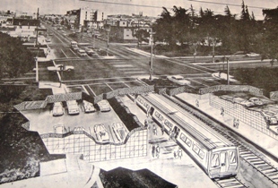
Artist's conception of a proposed BART station below Geary and Park Presidio Blvds

The idea was that a streetcar line above ground provided redundant service to the rapid, heavy rail line below. In later years the entire Geary corridor was further redesigned to move motor traffic more quickly. The end result in 2008 2009 is that one of San Francisco's most dense neighborhoods, the Richmond District, is drastically under served by transit; most riders funnel onto the 38, which is the busiest single line in Muni's system. The entire Geary corridor is the second most heavily-traveled, with 56,473 daily boardings along its four bus lines.

There are plans in the works (though currently years away from implimentation) to remake Geary with a bus rapid transit (BRT) line down the middle. One of the alternatives discussed in the official plans is to build a BRT right of way that could be retrofitted in a few years to run light rail (a reborn B-line?) from downtown to Ocean Beach. But why wait? Are we suggesting that Geary, with 30,000 more daily riders that pre-T Third St or 5,000 more daily riders than the N-Judah (Muni's busiest extant rail line), is less deserving of full-blown light rail than those lines?

Geary needs light rail now! More than that, it needs comprehensive transit options, with convenient local service and rapid cross-town access. Geary needs what Market St. has right now: A streetcar on the surface (preferably in its own ROW) to move neighbors to shops and provide convenient access to local amenities, and a subway line below to get commuters across town quickly.

Arguments that demand for transit need to be proven before a system so robust is built are flawed to begin with, but in the case of Geary, the demand for ridership is already proven. Induced demand has been proven in road projects, and a similar results can happen along "overbuilt" transit lines. To give San Francisco a web of transit arteries would be to build a system that is capable of accomodating growth for the future.

Sunday, December 28, 2008

Happy B-day Muni!


The Market Street Railway blog has the story. 96 years ago today then-Mayor James "Sunny Jim" Rolph personally operated the first run along the A-Geary line. The story of how San Francisco's first publicly-owned streetcar line came to be, and the deliberate collapse of it and the rest of the system half a century later is well worth a read. The Transbay Blog also has an excellent history.

There are many of us who would like to see the return of this kind of infrastructure investment. A renewed dedication to our publicly-owned mass transit system. San Francisco is a rare city in the US because it is possible to live here without owning or ever using a car. But those of us who do live our car-free lives here can't help but feel the strain of a piecemeal transportation system that routinely takes second banana to private auto traffic on our city streets.

Fortunately this region has no share of amateur visionaries who have put together their dream maps of public transportation in SF and the Bay Area:

Transbay Blog

SF Cityscape
The Overhead Wire

I've got my own ideas, which I'll get around to illustrating as beautifully as these someday. The Overhead Wire describes the benefit of these fantasy maps very well:


Why do I love fantasy transit network maps? Because unlike bus and automobile, it inspires people to think big and imagine. I think we could use some imagination these days. I've always believed it was good for you.


Monday, December 22, 2008

CVC 22500(f)

No person shall stop, park, or leave standing any vehicle whether attended or unattended, except when necessary to avoid conflict with other traffic or in compliance with the directions of a peace officer or official traffic control device, in any of the following places:


(f) On any portion of a sidewalk, or with the body of the vehicle extending over any portion of a sidewalk, except electric carts when authorized by local ordinance, as specified in Section 21114.5. Lights, mirrors, or devices that are required to be mounted upon a vehicle under this code may extend from the body of the vehicle over the sidewalk to a distance of not more than 10 inches.

To report sidewalk parking in SF, call DPT at (415) 553-1200
Hit 1 for English
4 for "more options"
3 for "sidewalk parking"

Thursday, December 18, 2008

Forgive them, they know not what they do?

I ran across this gem while looking through the draft of the Better Streets Plan:
The California motor vehicle code requires drivers to yield to
pedestrians in marked or unmarked crosswalks, but many drivers
are unfamiliar with the details of the vehicle code.
Awesome. Part of creating a safer, more pedestrian-friendly street environment rests on infrastructure and policy making, but I really hope we can also re-develop a culture of personal responsibility. Driving is a privilege, not a right. Everyone behind the wheel of a car was required to take a test of their knowledge of the CVC, and they need to be held responsible for violating the code.

Tuesday, December 16, 2008

Pedestrianism Vol. 2


Pedestrianism Vol. 2 on Vimeo.

An on-the-ground look at one of the worst streets in San Francisco. The stretch of trash-strewn pavement below the Central Skyway is actually three streets that have been combined into an expressway below the elevated freeway structure. Division Street runs between the Caltrain yard and Bryant St. Division curves South at Bryant and the expressway becomes 13th St it crosses Mission. From Mission it becomes Duboce and gradually narrows and calms down. The Skyway leaves the expressway, curving North and touching down on Market and Octavia.

With three lanes of traffic along most of the road, the expressway has roughly the same road space as the freeway above it. Pedestrians trying to make their way along or across this stretch of town have to deal with loud, echoing traffic noise; multi-street intersections, often without Pedestrian signals; off- and on-ramps for the Skyway; incomplete sidewalks and illegally dumped garbage. The blight surrounding this freeway and the vacant Caltrans properties along its way is noticable for blocks in either direction.

In 1999 the Central Freeway was demolished back to Market Street. The stretch of Octavia Blvd along its former route has since blossomed. Regrettably, it is very unlikely that the Division/13th/Duboce traffic sewer has any hope of a similar fate.

One more reason to look forward to January

One of the best sources of livable streets news out there, NYC-based Streetsblog, is adding a third outlet to its expanding network - one I personally could not be happier about.

Streetsblog San Francisco will join the New York and LA chapters next month. This will give the Bay Area some of the best progressive transportation journalism in the world. Other well-renown local blogs include The Overhead Wire and Transbay Blog.


Friday, December 12, 2008

Why don't we do it in the road?


From Broken Sidewalk of Louisville, KY:

What a profoundly clear example of how stupidly sidewalks are often built. How evident that the people who build them or design them don't give them a second thought.

Every town has its own examples just as egregious as the ones Broken Sidewalk shows; an obvious example is the section of sidewalk below the 101 overpass in Pedestrianism Vol.1

Anyone else sick of this? In a nominally transit-first city like SF, why don't we start treating the rights-of-way reserved for private cars like this?

Monday, December 8, 2008

No Ped Xing


Duly noted. Photo taken on San Pablo in Emeryville.

Thursday, December 4, 2008

Pedestrianism Vol. 1


Pedestrianism - Royksopp - Sing A Song on Vimeo
.

Roughly 2-mile walk through San Francisco's Potrero Hill, Showplace Square and South of Market (SoMa) neighborhoods. In this video approximately one hour is condensed into 5 minutes.

Of interest is the number of vehicular code violations and obstacles to the pedestrian right-of-way that you can see in a typical trip through this city.