
Before the first week of 2010 is over I thought it'd be fun to look at the most popular posts of 2010:

Everything old is new again. Muni originally ran the H-line streetcar from the Panama-Pacific Exposition grounds in the Marina out to the edge of the mudflats at Potrero and 25th. With the vast majority of new development in the city slated for the "Eastern neighborhoods" of the Mission, Potrero Hill, and Bayview-Hunters Point, I think Muni should look at reestablishing that cross-town corridor as part of an expanded high-capacity, rapid transit network.
If it looks like a driveway, and the property owners defend it like a driveway, and DPT tows cars parked in it like a driveway it must be ... a vacant office.


Developers announced that their plans to rebuild the Potrero Terrace-Annex public housing complex included reestablishing the grid through the property. Technically posted in December of 2009, this post still received a huge number of views last year.
#7 The Oakland Streetcar Plan
Stanford student Daniel Jacobson's Oakland Streetcar proposal has blown up in local political and transit advocacy circles, and it's also gotten tons of national and international attention.
 #6 Hello BART
Oh, The Simpsons. Even after 20+ years that show can be very punny!

This one's a tiny bit embarrassing. After crunching a set of ridership data from BART, I published this map of how many riders are on every stretch of BART track. Then the BART rep who sent me the data wrote me back and said the set contained an error (damn Excel) and I should use a new set of more accurate data. I promised to re-crunch and re-publish, but got sidetracked.
My new year's resolution: to follow up on this!

...Please stand clear of the doors.

Remember when they tore down the Central Freeway? Remember how they stopped at Market Street and the North Mission and SoMa still have to suffer under its sooty turquoise oppression? Caltrans should definitely tear that sucker down, but we can't stop there. The street underneath is ugly even if you ignore the elevated structure. Here's my idea for how to fix that.
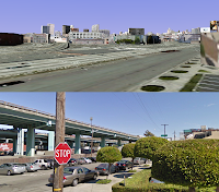 #2 Google Demolishes the Central Freeway
Google Street View's 3-D building models create an eerily familiar computer-generated San Francisco. But there's no 3-D model for the Central Freeway, which gives is a surprising peek at a world without that eyesore.
 #1 The Pulse of the City
From the brilliant mind of Eric Fischer comes one month of Muni's NextBus data overlapped into a visualization of a single 24-hour period. It's beautiful and enlightening, and it's at the forefront of what we're now able to see with GPS technology.


2 comments:
For all you people smoking funny stuff, think about how life on the ground would be IF that big ole ugly central freeway were gone and all that traffic were on the GROUND.
Think about that before complaining about a very GOOD way to get traffic above the people.
Hey Anonymous, thanks for the comment.
Fortunately we don't have to use our imaginations. Both the Embarcadero and North of Market section of the Central Freeway were removed, and in both cases the number of vehicles on surface streets was less than on the old elevated structure, with no resulting congestion.
The benefits to the street of removing an overhead structure far outweigh the traffic impacts of removing it. Feel free to do a Google search to find out more information.
Post a Comment