The image of public stairways in my mind is one of San Francisco's hilly neighborhoods - Twin Peaks, Liberty, Telegraph, Russian and Potrero Hills. But Oakland has hills too, and a group of people working to raise awareness of their Town's own public stairs.
The Oakland Urban Paths is a group of dedicated walkers, planners, historians and fundraisers with a common mission: to raise awareness of the paths and Oakland’s heritage through a variety of activities in partnership with Walk Oakland Bike Oakland (WOBO) and the City of Oakland.
Oakland Urban Paths is about to undertake an inventory of Oakland's 250+ paths and stairways. The effort kicks off tomorrow at WOBO's volunteer meeting. Deets have been added to the calendar in the sidebar, and listed after the jump
This edition is HD by Vimeo's standards. I recommend viewing it full-screen with HD on and scaling off.
This walk circumnavigates one of San Francisco's ugliest warts: the tangled maze of on- and off-ramps that connect Potrero Avenue and Cesar Chavez Street to Highway 101 while separating the Mission and Bayview Districts for car-free residents. Other liveable streets advocates have taken to calling this monstrosity the "hairball," and I'll use that term here as well since my own name for it is unprintable.
We start at Muni's Potrero trolly yard and maintenance facility, recipient of some much-needed Federal stimulus funds and end at the Flowercraft garden center on Bayshore Boulevard. Since the hairball cuts off the most direct route, down Potrero, across C Chav and on to Bayshore, I cut across 101 at the 18th Street Pedestrian bridge and over Potrero Hill into the Islais Creek industrial area of Bayview.
Things to note in order of appearance:
The steep slope of Mariposa between Potrero and Utah Street results in steps for a sidewalk.
Potrero Hill community garden is planted on former Caltrans land
McKinley Square park with its formal Victorian lawn and panoramic views
The section of Vermont Street adjacent to McKinley Square is curvier than Lombard, but far less famous
The lack of pedestrian crossings on C Chav, even east of the hairball, forces pedestrians to go out of their way around Kansas and Marin Streets, past the KOFY TV20 studios and Beronio Lumber
The Bayshore Boulevard traffic sewer with its merge turns and narrow sidewalks encourages motorists to drive recklessly. Note the failure to yield at 2:18
The Old Clam House is a San Francisco institution; a relic of the days when this area was wetlands surrounding Islais Creek
The old Whole Earth Access and Goodman's Lumber buildings. Locals remember these places fondly; the latter is the site of the ever-controversial and endlessly reincarnated proposed Big Box Home Center store
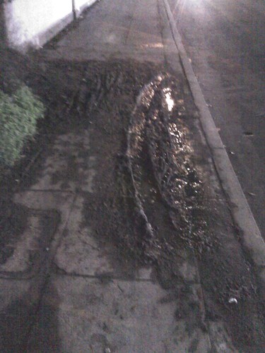
Excuse the crappy cell phone pic. This mud flow on 16th St. below Franklin Square Park has left the sidewalk barely passable for even able-bodied people for months now.
This slick, smelly mud pile has been blocking the South sidewalk of 16th St (across from the Potrero Center Safeway) for months now. I just reported it to the city using the new online version of the popular 311 service. The section of hill here, on the edge of Franklin Square Park, is un-retained, and the mud has been spreading for years. Note the tire track right through the middle of it. I would hate to have been walking down the sidewalk when whoever did that skidded across.
While trying to find an address to use to alert the city to its approximate location, I made an interesting discovery. This section of sidewalk is an intersection!
This screenshot of the SF City Assessor's map shows Hampshire St continuing to 16th Here's a Google map of the area for comparison:
How would it improve this unnecessarily blighted block to open Hampshire up to through traffic, even perhaps with a set of public stairs (leaving it a dead-end to cars)? Any public space here would have to be well-planned, because Franklin square is notorious for homeless encampments. But a streetscape that encourages the flow of pedestrian traffic (instead of mud) could bring life back to a block that's been neglected for too long.
The opinions expressed here are my own and do not necessarily reflect the views of my employer or any group I'm affiliated with.
Email: pedestrianist [at] yahoo [dot] com




 Posts
Posts


